 Now that I have Wildwood Trail, the roads, and all the firelanes under my belt, I’ve decided to polish off the remaining trails. Many more exist than the 2011 Hiking and Running Guide to Forest Park map shows due to trail building. The Forest Park Conservancy gives you a “free” map with your $25 registration fee for the All Trails Challenge but Portland Parks has a truly free one online, as in sans wallet.
I addressed the trails from north to south, rural to urban, respectively. In a nutshell, I can tell you that if you want a quiet hike of sublime serenity, your odds are better if you stick to the trails north of Firelane 1. That seems to be the cut off line for pounding mobs of frenzied trail runners and most of their organized races. There’s less city noise pollution up there, too. A good rule of thumb is any trail wider than 18″ in Forest Park is a popular one and likely to be rolling dust cloud or an oozing mud pit, depending on the season. Narrower, overgrown routes typically deliver a more natural forest experience.
Elevation gains noted below are to the nearest ten feet on Google Earth for one way hikes, though distance is doubled for the round trip (RT) hikes I actually took.
The Tao of Slug 6-25-11 to 7-20-11 Wildwood Trail 5,160′ elevation gain, 60.32 miles RT
This is the longest and most varied route in all of Forest Park, spanning it’s entire length from north to south. I wrote up my extended adventures on it in a separate post.  8-30-11 Keyser Trail 50′ elevation gain, 0.70 miles RT
Keyser Trail is the little divergence that loops south off Firelane 10 and then returns back to it again. It looked more like a firelane to me than a trail, so I did it during my firelane sorties. It’s fairly nondescript and had a few impressive blowdowns across it while I was there but it was nice and quiet. 8-30-11 Linnton Trail 420′ elevation gain, 1.16 miles RT
At the bottom of Firelane 10 is the top of Linnton Trail, which leads you down a veritable ladder of tiny switchbacks to a creek, a bridge, and a Y junction (above).  Go right and you’ll head straight to a route 16 bus stop on Highway 30 (right). Go left and you’ll climb some stairs out of the Forest Park boundary, curve around a while, and find multiple user trails, the most obvious of which ends at NW 3rd Street in the city of Linnton, itself. There is zero parking there and multiple unfriendly dogs, so turn around fast if your hiking partner is on a leash.
Cartilage lichen  9-29-11 Cannon Trail 160′ elevation gain, 0.64 miles RT
Cannon Trail connects the Wildwood Trail parking area to the Leif Erikson Road parking area below with an easy, ambling trail suitable to any hiking level. For these reasons, it tends to be crowded but at least it is a cinch to follow. Traffic on NW Germantown Road is highly audible the length of the route.
9-29-11 Tolinda Trail 430′ elevation, 1.5 miles RT
Tolinda Trail is unmarked at its origins on Leif Erikson Road, a mere mile from Leif’s NW Germantown Road trailhead. If you look for a wooded berm with a trail sneaking around to the left at milemarker 10.2, that’s Tolinda (below). The trail takes a sharp downhill turn and stays relatively steep the entire way to it’s parking area off NW Germantown Road (just Google 9401 NW Germantown Road, it’s right across the street). The route is rife with toe-stubbing tree roots and
  knots, so keep your eyes peeled. Look around for tasty Pacific Blackberry in late summer. There’s also a collection of tall, rotting snags where I saw three different kinds of woodpeckers in the space of five minutes: Red Shafted Northern Flicker, Red Breasted Sapsucker (right), and Pileated Woodpecker. They didn’t pause very long for photos but I did get serenaded by all three: nice.
6-30-11 Hardesty Trail 380′ elevation gain, 1.12 miles RT
Hardesty connects the top of Firelane 7 with Leif Erikson just before Leif’s 9 mile marker. It’s short, steep, and quiet–a convenient tangent to avoid the crowds in the Springville Road parking area who usually opt for the road or the firelane. About 180 yards south of Hardesty’s intersection with Wildwood Trail, on the north side of the trail, stands the noted Big Stump, a remnant of old-growth cedar with a pair of springboard notches cut into its trunk that resemble eyes.
Banana Slug inspecting a slime mold. Mmmmm, slime mold.
7-4-11 Trillium Trail 200′ elevation gain, 0.50 miles RT
There are multiple steep spots in Forest Park but Trillium Trail is the closest to a StairMaster. Head here for a quad warmer, just watch out for wild bee hives and wasp nests in the tall, lightning-scorched snags along the trail. These six-legged nature lovers will ignore you if you keep moving down this fastest route to the middle of Wildwood Trail (milepost 18.57) and an intersection decorated by the North Fork of Doane Creek.  9-17-11 Ridge Trail 980′ elevation gain, 2.70 miles RT

Mossy maze polypore mushroom (Cerrena unicolor)
The most beautiful trail in Forest Park has a dirty little secret. It starts out okay about a third of the way down Firelane 7 with a straight, shallow shot through the trees. At Wildwood Trail, it shifts onto a steeper track with a more open understory. Below Leif Erikson, it opens up into full-on cathedral ceilings of Vine Maple and makes elegant, sweeping loops around ridges and drainages (above). Be advised: the “Hiking and Running Guide to Forest Park” is wrong. It shows Ridge Trail jogging to the right where it crosses Wildwood but here it crosses directly. It shows Ridge Trail crossing Leif Erikson directly but it actually jogs left (north) before doing so. 
The “dirty” part comes near the bottom where multiple user trails strike off into the woods. Firelane 7 and Waterline Road may have transient camps, but Ridge Trail has a transient metropolis. I stopped counting after nine camps. Yes, you read that right, and all of them are carpeted with garbage, debris, and human refuse. The signs close to the bottom of Ridge Trail (where it makes a Y into two separate insertion points along Bridge Road) encourage you to make a right and I concur: Most of the camps are to the left, but so is a spectacular view of the St. John’s Bridge (above left). This left route makes one switchback and sends you to a bridge that vaults Bridge Road over a deep gulch and private residence. However, if you turn right at the signs instead, you won’t miss out. When you see a well-constructed little wooden bridge up ahead, get your camera ready because the St. John’s Bridge has more than one good side (below). 
 The end of Ridge Trail is those concrete stairs you’ve probably passed on Bridge Road and wondered about (right) where the sidewalk leads to route 16 bus stops on Highway 30. Atop that concrete wall is a disintegrating patio with evidence of what might have been a viewing area for the St. John’s Bridge at one time.
9-29-11 Wiregate Trail 180′ elevation gain, 0.62 miles RT
The only quick way to get to Wiregate Trail is to take Trillium Trail down to Wildwood Trail from the Springville Road parking area–so you can add that bit of incline to Wiregate’s otherwise benign descent. Wiregate itself is fairly wide on its lower half–obviously a former road–but because it hugs a creek so close in such a steep-sided little gully, there’s a fair amount of year-round moisture and Stinging Nettle to contend with. Wiregate drops you off on Leif Erikson at a nice bend at mile marker 7.13 where the selfsame creek opens a bit into a mini-meadow. 
9-25-11 Quarry Trail 70′ elevation gain, 0.25 miles RT
The Quarry Trail is one of the youngest trails in Forest Park but it’s worth taking this little connector from Leif Erikson to Maple Trail. It’s easy to find: at that famous rest spot on Leif Erikson with the picnic table where Saltzman Road passes by, look for the Quarry Trail sign right there in the Himalayan Blackberries. The brambles only last a few yards, then the soft, moist forest takes over and you’ll enjoy a gentle grade for about a quarter mile. I saw my first Northern Pacific Tree Frog there (above left). He was about two inches long and in his brown morph, attempting to blend in with the leaves. Somebody should have told him that you gotta stop hoppin’ if you wanna start hidin’. 9-25-11 Maple Trail 1230′ elevation gain, 7.04 miles RT
Maple Trail is officially my favorite trail in all of Forest Park. It’s peaceful, lovely, easy on the knees, and relatively devoid of people–I’ve never seen more than two on the entire trail. It crosses two sizable creeks, providing critters of the aquatic persuasion (above) as well as the furry sort that chatter aloft (below). At just over 7 miles long, round trip, Maple Trail gives you a decent workout. The best way to reach it is to park at the top of Firelane 2 and head down, taking a left (north) on Wildwood Trail. Just a few hundred feet up from there is Maple Trail. There are five intersections with firelanes, trails, and connectors before Maple concludes at a bend in Leif Erikson (milepost 6.44), so you have plenty of options. Wear the waterproof gear if it’s raining; you’ll brush by so many dripping leaves that you’ll be wringing out your pants by the time you get back to your car.
Looking down to Maple Trail from Leif Erikson near mile post 6.4.
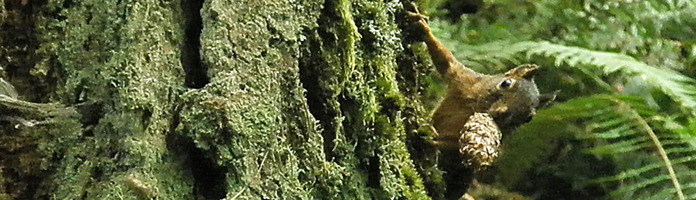
 9-23-11 Cleator Trail 200′ elevation gain, 0.48 miles RT
Short ‘n’ steep, Cleator Trail connects Wildwood Trail at milepost 15.47 to Leif Erikson at milepost 5.45. It’s so steep in one spot that trail crews have worked hard to create a serpentine dance of mini-switchbacks in order to prevent erosion. It’s kinda cool lookin’ and makes it a more interesting trail. Also interesting are the frenetic little pine cone-chewing residents (above left).
Mossy Maze Polypore mushroom 9-23-11 Koenig Trail 240′ elevation gain, 0.56 miles RT
Koenig Trail is a thimbleberry lover’s delight. It’s absolutely lined with them from its beginnings at milepost 14.23 on Wildwood Trail to it’s intersection with Leif Erikson at milepost 6.44 below. That part is steep, then it jogs north slightly as it crosses Leif and continues on down in a more gentle decline to Maple Trail near Saltzman Creek.
Discarded termite wings from a recent swarm.
9-17-11 Chestnut Trail 240′ elevation gain, 0.98 miles RT 
Like Nature Trail beside it, Chestnut Trail is easy on the knees. It has a gradual incline and nice little bridge across Rocking Chair Creek, plus uplifting sentiments (right). Near it’s intersection with Leif Erikson, this trail sports an unequivocal message to illegal mountain biking (below). 
 9-17-11 Nature Trail 310′ elevation gain, 0.56 miles RT
The Nature Trail probably has the kindest incline of all. Used for educational nature walks for children and adults, it is well maintained. Gooey critters abound (left) and (below). Getting to it involves a little downhill stepping on Firelane 1 but after that, it’s very smooth. Just past the halfway  mark, it jogs upwards slightly and offers a short connector to Wildwood Trail above. If you decide instead to continue downward along Rocking Chair Creek, you’ll pass through the only gate I’ve seen on a trail in Forest Park (below) and get a good look at a recent rockslide where Chestnust meets Leif Erikson. Don’t worry, the trail is diverted around it.
 7-13-11 Morak Trail 40′ elevation gain, 0.2 miles RT
This handy little connector to Wildwood Trail is far curvier than the map depicts. It cuts the journey down Firelane 1 in half so you can hop onto Wildwood at mile marker 10.65 instead of 11.18. There’s not much else to say except that it’s a cool name, Morak.
Into every caterpillar’s life, a little rain must fall.  9-14-11 Alder Trail 290′ elevation gain, 1.68 miles RT
Alder Trail is a quiet, peaceful stroll. All the trail runners tend to pound along Wildwood, Dogwood, and Wild Cherry, leaving Alder to itself. It’s a delightful way to get onto Leif Erikson if you don’t want to deal with the parking situation on NW Thurman Street. Down at the bottom, you’ll pass through a beautiful stand of its namesake, a grove of Oregon Alder (below) where a bronze plaque describes the trail’s origins in 1980.
 9-14-11 Keil Trail 80′ elevation gain, 0.34 miles RT
Keil Trail delivers you to the intersection of Dogwood and Wild Cherry from a parking area 0.5 miles north of the official Birch Trail parking lot. This mostly flat trail sports a wooden fence reminiscent of the ones settlers used (right).
Shelf fungus catching raindrops. 9-14-11 Wild Cherry Trail 500′ elevation gain, 1.76 miles RT
Dogwood follows a ridge for most of its length and has some large switchbacks. Very popular with the trail runners, it’s neither a quiet nor solitary experience. Because it’s one of the first few intersections with Leif Erikson from the NW Thurman Street access, it gets that crowd, too. The most popular (read: busy and noisy) loop in all of Forest Park is the one that encompasses Dogwood, Wild Cherry, and Leif Erikson. If you don’t want to be alone in the forest, go there, you won’t be.
My weirdest memory in Forest Park involved Wild Cherry Trail. I was walking along Leif Erikson when I heard a man shouting “Wild Cherry! Wild Cherry!” at the top of his lungs as he ran the length of Wild Cherry Trail above me at full bore. When he exploded out onto Leif, he seemed to be in some sort of ecstatic trance, eyes squinted shut, long hair and beard whipping around his face as he ran. I laughed and waved. Hey, whatever gets ya there, buddy.  Wild Cherry Trail enjoys some impressive trail improvements that cured its muddy spots while maintaining a curvy route still studded with root bumps and knots, so watch your step. A majestic Horse-chestnut tree arches giant limbs over the trail just past the ancient picnic table near the Leif Erikson intersection (above). Wild Cherry is very popular with trail runners (see Dogwood Trail above).
Even caterpillars have redheads. 9-29-11 Birch Trail 130′ elevation gain, 0.44 miles RT
Birch Trail is the loveliest little access trail to Wildwood Trail in all of Forest Park. Its switchback are gentle, its incline mild, and it plops you right on Wildwood at a nice wooden bench suitable for meditation or canoodling. There’s ample parking up on NW 53rd Avenue and the mowed areas there are suitable for blankets and picnic baskets. Here, I witnessed the odd and rarely seen courting ritual of the Forest Park Wheelbarrow (below). Apparently, when the trail crews knock off for the day, the wheelbarrows all get together and do a little canoodling of their own.  9-30-11 Aspen Trail 170′ elevation gain, 0.46 miles RT
Aspen Trail is probably a mystery to all but those who live in the adjacent neighborhood, but it’s a handy way to reach Wildwood Trail without dealing with the frenetic parking situation on NW Thurman Street. Tip: Park as close as you can get to 3418 NW Thurman Street and look for these public stairs on the north side of the street ascending past the maples up into a grove of bamboo (below).
 It’s bamboo all the way up, you’ll think you’re in China. Warning: There’s a very large buckeye tree that releases an occasional shower of large, hard seeds (right) that will put a damper on your day and a dent in your noggin, so keep it moving if you’re hiking in early fall. When you reach NW Aspen Ave at the top, go right and look for the sign heralding Aspen Trail (below).
  From there, it’s a relatively easy incline of wide trail and sparse understory. In fact, it almost looks as if everything other than fir and fern has been selectively removed. The result is a clean view, full of space, but it’s also a popular trail, full of people.
  9-30-11 Lower Macleay Trail 260′ elevation gain, 1.72 miles RT
Lower Macleay is the most enchanting stroll from city into forest in all of the Portland Metro area and sometimes it seems as if the entire Portland Metro area is there, getting enchanted. It’s not a good place for silent meditation but it’s definitely worth experiencing the elegance of Balch Creek, a rare four-season source of watery music and intermittent reflecting pools (above & below). The trail begins in Upshur Park so parking on NW Upshur can be a bear during peak hours but if you park along NW Thurman above it, you can take the stairs down next to the bridge. The initial quarter mile of Lower Macleay Trail is paved to provide access for all abilities and leads to a nice little walled patio overlooking the water. After that, the trail becomes a sometimes-gravel-sometimes-dirt dance partner with the creek.
 This little waterfall (above) feeds a deep glassy pool decorated with ferns and undulating with Cutthroat trout (below). There’s a nice wooden bridge spanning it that you can lean over during fish finding. The largest I spotted was six inches long (right) but you can spot fry up and down Balch Creek, as well as crayfish and newts. Just hold still and wait.
Your reward at the end of Lower Macleay Trail–as if soaking up the dewy ambiance of some humidified creek air isn’t reward enough–is the historic and picturesque Stone House (below). Built in the mid-1930s by the Works Progress Administration (WPA) as a public restroom, its water line was destroyed by the infamous Columbus Day Storm on October 12, 1962. The structure was gutted to its stones and left as a curiosity and resting spot at Lower Macleay’s intersection with Wildwood Trail. 
You can climb stairs on either side of Stone House to reach the upper floor (below).
9-30-11 Macleay Trail 50′ elevation gain, 0.56 miles RT
 Macleay Trail branches off from Wildwood Trail a few hundred feet up from Wildwood’s NW Cornell Drive crossing. There is a two-tier parking area on NW Cornell (right) and the Portland Audubon Society Sanctuary is just down the street. Traffic noise is abundant, but after the initial ascent from the road, Macleay is easy and wide with a sparse understory and spacious feel. At its next intersection with Wildwood–a confusing one for most, check your map–it becomes Upper Macleay Trail.
 9-30-11 Tunnel Trail 140′ elevation gain, 0.34 miles RT
Tunnel Trail will always hold a special place in my heart as the final trail I completed in my goal to hike the entire Forest Park system. It does not disappoint: It’s short, steep, it ends right next to a handsome 1940 stone tunnel on Cornell Drive, it has plenty of parking there as well as a grassy lawn, and it follows a moist drainage the entire way down, ensuring a steady supply of wildlife like giant (but harmless) cross spiders (above left) and a variety of fungi. This extreme close up of Stemonitis slime mold, which is only 3/8″ tall, looks just plain weird (below).
I also got a treat seeing my first Pygmy Owl in the wild. He was the size of a fat sparrow and pretty brave perching just six feet above me and peering down, unaffected. Unfortunately, he turned his head just as I snapped the photo below and I did not get another chance. It was worth it. 
9-30-11 Cumberland Trail 140′ elevation gain, 0.82 miles RT
Cumberland Trail starts a little further down Wildwood Trail from Upper Macleay. It’s a relatively flat, wide trail to a Forest Park access point at the end of NW Cumberland Road which has far better parking than NW Macleay Boulevard just up the hill. Tunnel Trail branches off from NW Cumberland about midway along its length and plunges down a drainage to NW Cornell Road below.
Excellent quote on the back of a bench along one of the Macleay trails: 

Oregon geranium (Geranium oreganum)
9-30-11 Upper Macleay Trail 210′ elevation gain, 0.81 miles RT
Upper Macleay Trail begins where Macleay Trail ends at a discombobulating intersection with Wildwood Trail. There are signs helpfully pointing the way but the trails come together at such nonsensical angles that it plays tricks with the mind, especially at dusk, so don’t attempt to navigate this one in the dark. Many have lost their minds. Like Macleay, Upper Macleay has an easy incline and an open understory. It cuts a long switchback, making its turn at a Forest Park access at the end of NW Macleay Boulevard, then meeting up again with Wildwood further down the hill. Do not look for parking on NW Macleay Boulevard, you’ll just leave defeated.
Pileated Woodpecker graffiti
Well, that’s it, that’s all of Forest Park. From June to September, I made seven new friends (ten if you count the canines), obliterated a brand new pair of walking shoes, burned fifteen pounds, and brought a favorite pair of Columbia hiking pants dangerously close to the end of their life. I saw the forest in the morning, afternoon, and evening in sweltering heat, chilly fall air, dripping humidity, and intermittent rain. I feasted on wood sorrel, red huckleberries, two kinds of blackberries, Thimbleberries, and Oregon Grape. I hiked upwards of 200 miles when you account for the extra stretches of access trails and the fact that most of the journeys were round trip. I learned a lot of history about the area and finally made a one-time contact with a warm body at the Forest Park Conservancy, albeit never again. I slept better at night than I have in years. And I did all of this completely unaware that a program called the All Trails Challenge was running simultaneously to my personal expedition. (I thought of it first, so neener, neener.)
Now, if anybody stops me in Forest Park and asks if I know where a trail goes, I say, “Hell, yeah.”
Happy (slug) trails to you, until we meet again….

Pingback: Forest Park Firelanes 2011 | All Thoughts Work™ Outdoors
Pingback: Wildwood Adventures of Forest Park 2011 | All Thoughts Work™ Outdoors
Pingback: Forest Park Firelanes 2011 | All Thoughts Work™ Outdoors
You missed one – As you enter Holman Ln. from the top, you go through the gate and about 50 yds past on the left is an unamed trail that heads east , passes a bench, an old water well, and into a clearing that looks like it was probably logged years ago. If you keep going it dumps you out onto Wildwood as it levels out, after the climb past Aspen trail junction. It’s steep coming down, but a cool trail.
If you can confirm with Friends of Forest Park that it is an approved, named, and mapped trail and not another destructive user trail, I’d be happy to hike it and add it, thanks.
I volunteered up at the park recently, and found out that it’s preferred this trail not be used. It used to be maintained – there’s a nice bench to rest on about 100 yds in, but after that it’s being restored to natural habitat.
Thanks for the update, Kevin, that’s good to know. The forest definitely needs a rest. There are a lot of heavily damaged areas from illegal mountain biking, too, that will take decades to heal.
If I could ban all bikes to just Forest Park roads, I would do it in a heartbeat.
I just wanted to say kudos for the fantastic resource you’ve crated here. I really dig running on the trails up in Forest Park, and between this and your firelane write up, I realize that I’ve barely scratched the surface! Very nice work!
Thank you, Greg, that’s why I wrote it. Well, that, and bragging rights.
I like to get a feel for a trail beforehand in order to psyche myself up for the day but few hiking books tell me the kind of stuff I want to know. So, I add these details in my stories for all the people like me who like it peaceful and problem-free in the woods.
Because anyone who’s tried to park at the south entrance of Leif Erikson on a summer weekend after 10 A.M. has seriously thought about doing harm to his fellow man.
Question for you – I’m new to Portland and I’m finding your blog invaluable! You’re the kind of runner I dream about, haha! I ran up St. Helens Road to the Saint Johns Bridge the other day and passed the Ridge Trail, and now I’m back to read your review. What’s your advice on directions if I’m coming from this side? (I don’t have a car so anything I want to do, I do in my running shoes, lol). I was thinking I could see more of the northern parts of Forest Park if I run up to Ridge Trail and hit Wildwood from there.
Hey, welcome to Portland! The comedian Jim Gaffigan said people in Portland dress as if a hike might break out at any moment. Yer damned right, Jimmy.
OK, strap in.
Your plan to come from the north and east is genius because you’ll skirt the crowds. If you’re an early riser, that helps, big time. Only downside to being the first one on the trail is all the cobwebs you’ll be eating (our orb weaving forest spiders are harmless) but it’s a small price to pay for nirvana. I’ll give you northern Forest Park from St. Helens road starting points so you have shorter mileage options if you take a bus out but you can get to all of this from Wildwood, too. Hell of a long run, though.
You’ve got 8 options that meet St. Helens Road directly or via shortcuts, from the St. Johns bridge on north: Ridge Trail, Springville Road, Tolinda Trail, Firelane 9, Linnton Trail, Newton Road, Firelane 12, and BPA Road. I’ve been hiking other places than Forest Park almost exclusively since 2011, so things might have changed a bit, but I’ll tell you what I know.
Ridge Trail is going to be the most populated, littered, and probably dangerous, especially now with increased homeless camps. Do it at dawn and you’ll solve most of that.
Springville Road is long and lovely and mountain bikers sometimes tear down it like Speed Racer. Again: dawn. Do it all the way up to Skyline Boulevard and then loop back down on Hardesty and Ridge Trails.
Tolinda Trail is best avoided altogether. It’s a steep little mutha that the mountain bikers have adopted, full of roots and drops. Also, you have to go up Germantown Road to get to it and Germantown is nothing but blind curves full of heavy traffic and no shoulder. Runner’s suicide.
Ditto Firelane 9 unless you sneak up into it from the neighborhood below and then keep going on Cannon Trail. I’m not into traffic noise, though, so….
Linnton Trail into Firelane 10 is a little darling right off a St. Helens Road bustop but that makes it popular. Too popular. Dawn.
My three favs are Newton, BPA, and Firelane 12. Hardly anyone does Newton because it goes from road to narrow trail at the bottom but that’s why I like it. Variety. You’ll be pushing past undergrowth near the creek but it’s all cool and jungle-y and you’ll have a great chance of seeing wildlife. DEET is your friend here.
BPA is road from top to bottom and an exposed road, at that. Read: Hot as hell under full sun, bring all the water you can carry. But the view is fucking awesome up there. Best to go up the evil incline from the St. Helens Road, take a jaunt over to Firelanes 13 and 13A if you feel like it, there’s a view of the Sauvie Island Bridge there, hang a left on Wildwood Trail, and then loop down on whatever trail suits your fancy.
I saved the best for last. Firelane 15 is the only trail I still visit in Forest Park. It’s remote, it’s shaded road, it has two tasty views, and it hooks up with myriad other stuff. You can come at it come Firelane 12 off St. Helens Road (there’s a bus stop) or from Wildwood Trail but do come at it. Take it all the way up to Skyline Boulevard and you’ll be rewarded with the only view looking west. Blackberries up there, too, om nom nom.
Okay, I lied, Firelanes 2 and 3 will also take you to Skyline and the western vistas but you’ll have to veer north on the sidewalk at the top a little bit to see them. Totally worth it at sunset, though. Especially if you go half a mile to the memorial gardens and find the marble benches at the top near the Grecian columns.
Lace up!
(map)
Thank you!! At least a month of long runs here 🙂 It’s nigh impossible to ask a Portlander what you can get to on the bus and I learned the hard way that Germantown and Saltzman are Uber only. This is great!
You’re very welcome and thanks for the heads up about Germantown and Saltzman.
Are you an ultrarunner? I’ve met a lot of you in Forest Park. Wildwood Trail is 32 miles long, so an out-and-back serves you well but beware the mud in wintertime.
Some do a Wildwood-Leif Erikson loop somehow but they stay off Germantown. Seriously, that road is psychotic at rush hour. Barnes, too.
It was fun to take a trip down memory lane into Forest Park, thanks for the “exercise”–Ha, ha!
PS: There used to be shuttles up the Columbia Gorge and up to Mt. Hood. I’m not sure what’s still running COVID-while, but it would be a hell of a day. Lots of good trails up there.
I’m actually a road runner, but having been forced to move to Portland about a mile from the Thurman trailhead with no car, Forest Park is one of the only local options I enjoy. Besides doing speed work in the industrial district, lol (the truckers are actually quite nice and I was offered a job at a strip club!) I’ve looked up the shuttles you mentioned and they’re still there! Thank you!! Pandemic allowing, I’m doing a race at about 5000 ft in September so I was hoping there was a way to get a couple of runs in somewhere on Mt. Hood. Your blog has really inspired me, I check it every time I plan a run on a new route and I see a good way to make use of the things we love to do every day 🙂
Fantastic! (On the race, not the no-car. That sucks.) I can give you some good advice about training for altitude, after 23 of the tallest mountains in the U.S. under my belt. I’m not a runner but I understand intensity.
First of all, no one really understands what causes altitude sickness, exactly. Some athletes get it and some couch potatoes don’t, so if you’re feelin’ it up there, don’t blame yourself. It’s a weird thing.
For 72 hours beforehand, avoid alcohol, sugar, and caffeine–anything that will cause inflammation. You want your capillaries happy, loose, and ready to work. Stay hydrated, before, during, and after–it’s often the only thing standing between you and a thumping headache. Get good sleep, sleep like your life depended on it. Lastly, train twice as far below as you will run up high; if you’re doing a 5K race on a mountain, make sure a 10K is a walk in the park first.
Lastly, whatever deep breathing exercises, meditation techniques, and visual motor rehearsal you do daily to stay centered will really help. Your body can handle altitude fine, it’s the mental unknown that freaks most people out. Believe you’ll be fine and you will be, the body takes its orders from the mind. Not the brain, the mind. Big difference. But, as an athlete, you already know that.
Kick ass!
PS: Visualization and directed thought are more powerful than most realize. I’ve caused amazing changes in my own body acutely and over the long term with those practices. Something as simple as getting in a good mood beforehand can inoculate you against many evils, literally and figuratively.